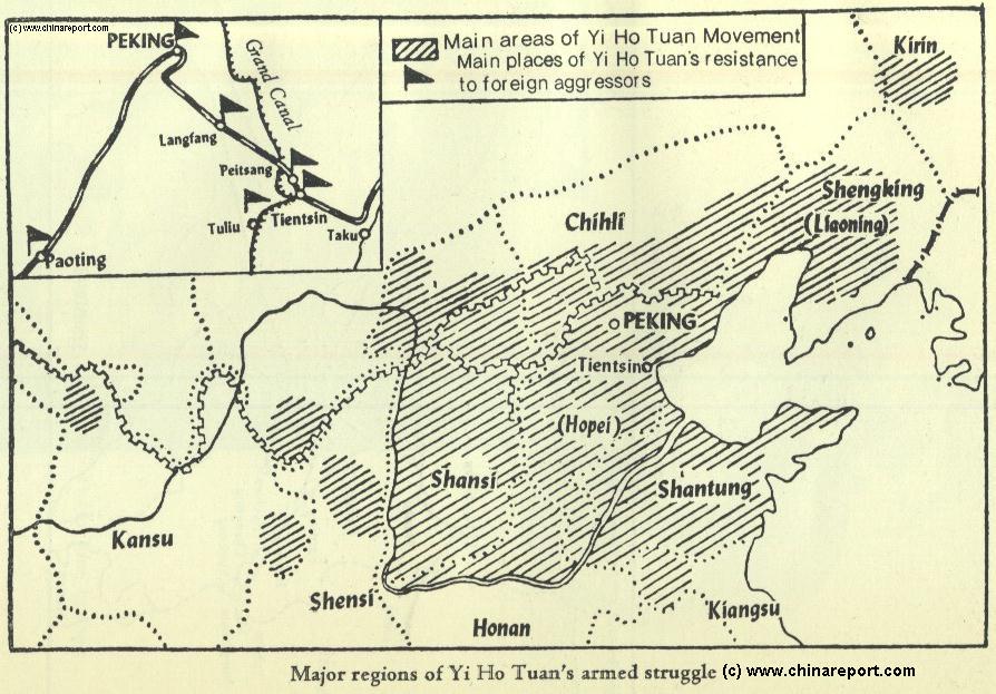
The below Schematic Map depicts the extend of the Base Areas of the Yi Ho Tuan (义和团 - Yìhétuán) also dubbed the 'Boxer Movement' or Society of the Righteous and Harmonious Fists.
The Yi Ho Tuan were initially a 'secret society', but in 1899 AD/ 1900 AD evolved into an armed rebellious movement, which ignited Civil War in a large part of the dying Qing Dynasty (1644 AD - 1911 AD) feudal Empire of China.
As can be deduced from the below Map, the initial uprisings appeared in Shandong Province, from there rapidly spreading into Hebei Province and to the Cities of Beijing and Tianjin. Outside of Beijing the historical 'Marco Polo Bridge' (Lugou Qiao) and Wanping village were occupied by the rebels, cutting telegraph and railway connection between the coastal colonies and Beijing, as well as with the rest of the Nation. Although it was an uprising against the rule of the Qing Dynasty, the rebellion carried equally strong anti-foreign sentiments. In the initial skirmishes two Foreign Diplomats were assassinated on the Streets of Beijing, whereas direct attacks on Foreigners, mainly Foreign Missionaries, their Churches and families occurred throughout the Northern Provinces and wider nation.
As clearly depicted on the Map, the 1900 AD Rebellion went on to sweep the entire North and a large part of the North-East including Shandong Province, Shanxi Province, current day Hebei Province and large parts of Inner Mongolia Autonomous Region and Liaoning Province, thereby encircling the political and Dynastic National Capital of Beijing. During the summer of 1900 AD Foreigners in Beijing were driven back to their Embassy Compound, the so-called 'Beijing Legations Quarter', where they were nearly annihilated by their Chinese Adversaries, if not for the overwhelming fire-power and substantial military detachments concentrated in the small Embassy District. As further shown on the map, minor skirmishes occurred in North Shaanxi Province and as far away as the Kirin Region in current day Jilin Province in Manchuria and the region of Wuwei in Gansu Province, the latter underneath the Great Wall of China.
The Set-In window provides a schematic of the railway line and telegraph connections between the coastal City of Tianjin and the Imperial Capital of Beijing where the Foreign Embassies were located. Tianjin had been raided by the British in 1858 AD and was declared a Treaty Port under the Tianjin Treaty of 1860 AD. Since, telegraph connections as well as a railroad to Beijing - the first in China- had been established, both of which had been secured under 'International Control'. In other words, at set intervals the railroad was guarded by Foreign Troops (British and American), who became the targets for an army of Yi Ho Tuan members heading from Tianjin towards the Capital of Beijing. Read More below the Map >>>
The China Report
Datong
Zhengzhou
Wuwei
Historic Map Extend Yi Ho Tuan Movement & Boxer War in NE China + Flight Empress- Dowager